

In October of 2015, residents of Charleston experienced a historic level of flooding as the city received nearly 25 inches of rain in two days, leaving thousands (including myself) without power or isolated by deep flood waters. Meteorologists called it a “1,000-year-rain event.”
This week, just nine years after that atmospheric freak occurrence, the city is bracing for rains that are even more torrential, thanks to Hurricane Debby, which hit Florida as a Category 1 on Monday and is expected to reach South Carolina as a tropical storm this week.
There are a few differences between the two events. The 2015 storms were not tied to a tropical event. The expected inundation this week, which could see upwards of 30 inches of rain hitting parts of the city, are tied to Tropical Storm Debby. Both, though, underscore the impact of rising ocean temperatures.
On the Saffir-Simpson scale, Debby is not an especially scary storm. Most Charlestonians would have simply ridden it out and barely given it a second thought had it been following a normal path. Tropical storms are, after all, an inconvenient part of living along the Southeast coast. But meteorologists say Debby will stall around the time it hits the Georgia/South Carolina border, resulting in the massive rainfalls.
The worst hurricane season on record came in 2005—the year Hurricane Katrina wiped out New Orleans. That year saw 28 storms and seven major hurricanes. This year, forecasters warn, the tropical waters of the Atlantic are significantly warmer than they were then. In May, they were already approaching temperatures typically found in August. Those rising temperatures are due to greenhouse gasses warming the planet, say scientists.
Charleston is hardly alone in the intense rain. Houston, in May, saw up to 23 inches of rain in some parts of the city. Hundreds of people had to be rescued from floods, and at least one death was reported: a five-year-old boy who was caught in a car that was swept away by the water.
Forecasters had warned that the extreme weather the U.S. experienced last summer was not a one-off meteorological event. A report from John Nielsen-Gammon, the Texas State Climatologist at Texas A&M University, predicted more extreme events this year for that state, including excessive rainfall, noting that clouds produce about 4% more rainfall for every Fahrenheit degree the average temperature increases. That can alter weather patterns and increase the number of dangerous storms.
For residents of the South Carolina low country, the cause is less of a concern at the moment than what’s going to happen over the next few days. The Charleston branch of the National Weather Service says the city has already received 2.29 inches of rain as of 2 p.m. ET Monday, breaking a record. And the heart of the storm isn’t expected to hit town for a couple of days. Threat levels due to rain are expected to peak—at a level labeled “extreme impact”—later tonight and stay at that intensity through sometime on Thursday (when they drop to an only-slightly-less-imposing “high impact”).
Forecasters say the flooding could be “catastrophic,” and the National Hurricane Center warns “this is a life-threatening situation.”
Remembering the last floods
While Charleston has ridden out a hurricane or three since the 2015 rains, the flooding the city has experienced hasn’t been close to that level. One meteorologist, in 2015, did the math and estimated that South Carolina saw 4.4 trillion gallons of water fall from the sky during the storm.
Floods have come, though. Charleston experienced 75 flood events in 2023. A century prior to that, it saw just two.
While no two storms are alike, Charlestonians who were in the city in 2015 for the “1,000-year-rain event” can’t help but wonder if it will be similar. Here’s what it was like in the city in those days.
Downtown Charleston started flooding on the evening of Thursday, October 1, with the tourist-friendly Market Street area having several inches of water on the ground. Market Street, though, floods fairly regularly. All it takes is a sustained thundershower for that to occur.
The rain kept coming, though. And by mid-morning Saturday, October 3, the downtown flooding was dire enough that local police had started to shut down interstate exits to the area, along with inbound surface streets. Torrential rains continued through the night. Power outages quickly became widespread.
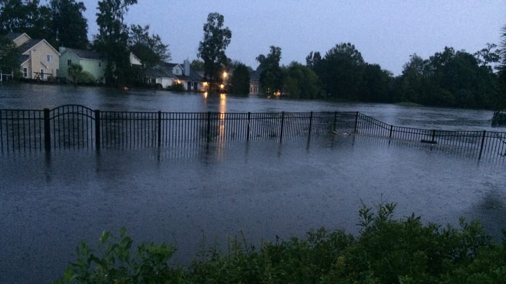
By the following morning, many parts of the city were under water and rescue crews were going house to house in affected areas, evacuating families whose houses had been breached. A popular golf course became so flooded that kayakers zoomed up and down the green. The city, eventually, had to buy out 32 homes in that subdivision, which had experienced flood damages. Those were demolished to create rain gardens and a green space to help reduce stormwater runoff.
Residents in the area are hoping that moves like these sorts of actions will prevent the flooding the city saw in 2015—but they’re not letting wishful thinking stop them from taking practical preventative measures. On Saturday, the city opened up five stations where people could fill sandbags to protect their homes.
At the station near that golf course/temporary kayaking river, the city dropped more than 110 tons of sand before noon and people were lined two deep to fill their bags.
A thousand years, noted one resident, isn’t as long as it used to be.